Monday, July 25, 2011

Interstate Flight

Today was my first cross country flight. As mentioned before, the FAA defines a cross country flight as 50 or more miles, so Bowling Green/Warren County Regional Airport (BWG) is a great option.

We logged a flight plan and we pre-check DA20 362DC, and noticed there was not sufficient oil pressure (or at least the gauge didn’t state there was). We had to abort, and then take DA20 223NH. Since we changed planes, we never opened up the flight plan.

To stay under the clouds, we flew at about 3,500 feel. The FAA states:

91.159 - VFR cruising altitude or flight level.

Except while holding in a holding pattern of 2 minutes or less, or while turning, each person operating an aircraft under VFR in level cruising flight more than 3,000 feet above the surface shall maintain the appropriate altitude or flight level prescribed below, unless otherwise authorized by ATC:

(a) When operating below 18,000 feet MSL and?

(1) On a magnetic course of zero degrees through 179 degrees, any odd thousand foot MSL altitude +500 feet (such as 3,500, 5,500, or 7,500); or

(2) On a magnetic course of 180 degrees through 359 degrees, any even thousand foot MSL altitude +500 feet (such as 4,500, 6,500, or 8,500).

(b) When operating above 18,000 feet MSL, maintain the altitude or flight level assigned by ATC.


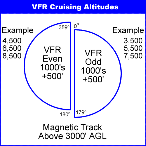
Since we were headed in direction North northwest (060 degrees) we need to stay at an odd number (plus 500 feet).

The sky was hazy but with enough visibility to see.

The real challenge to cross country flight is navigation. Without the use of technology, there are two main ways to navigate:

Dead reckoning is the process of calculating one's current position by using a previously determined position, or fix, and advancing that position based upon known or estimated speeds over elapsed time, and course. For example: if I leave the airport at 5:10 pm and I calculate it should take me 15 minutes to reach my first checkpoint (possibly a pond, road, or other landmark), then at 5:25, I can confirm if I’m on course. The pilot picks checkpoint every 10 to 15 miles.

Pilotage is the use of fixed visual references (similar types of checkpoints) on the ground or sea by means of sight or radar to guide oneself to a destination. For example, I know that I65 runs from Nashville to Bowing Green, I could just fly that route.

Since technology can fail, the FAA wants me to have an understanding of these types of navigation methods. We practiced them on the way to BWG, and found the airport with no problem. It took us about 35 minutes to fly there, where it takes about 90 minutes to drive.

One thing that was clear, was that the pilot’s workload is extreme when flying a cross country. You have to look at your notes, check the map, search of items on the ground, maintain course heading (which can be challenging with the wind) all while flying a plane at 120 knots per hour. On this first flight, I noticed I was not as organized or prepared as I would have liked. My CFI was with me, so I had some help, but I’ll need to make sure I have everything at hands reach at all times and anticipate my next task more efficiently.

BWG is an uncontrolled airport, meaning no ATC, and there wasn’t any traffic while we were there. No problems with landing or take off. On the way back, we used the GPS. In the future, I’ll most likely be using a GPS, so I need to be familiar with that as well. This greatly decreased the workload.

We landed back in Smyrna as dust was setting so they had already turned on the airport lights. It was very cool to see my airport all lit up. My landing was smooth and one of my best landings yet.

Flight time: 1.50 hours
Cost: Plane rental - $141.00, Instructor Fee - $72.00

Monday, July 18, 2011

Cross Counrty Flight Planning


This is how pilots view the world in their minds. This is a Sectional Aeronautical Chart, used to provide pilots with critical navigation information.


As part of my required training, I have to perform certain cross country flights. The phrase “cross country” invokes images of multistate flying taking hours or days. The FAA defines cross country flight as any flight over 50 miles. It just so happens that Bowling Green, KY is about that distance from Nashville.

Since it rained today, Adam and I took this as an opportunity to start planning our first cross country flight. Below are the items needed to plan a cross country flight. I know that everything could be replaced with a GPS, but the FAA requires that I know how to navigate manually. It is also a good practice just in case the GPS fails.


I did have to purchase a few additional supplies:

Fixed Plotter – it is like a rule and protractor combined ($9)


Pilot Operating Handbook for the Diamond DA20 – similar to an owner’s manual, but also provides information about performance, fuel usage, and limitations. ($22)


Aslo, I needed a Sectional Chart ($10).  We sent about an hour and forty-five minutes planning the trip, and going through all of the math required.

I later tried to replicate it on my own, but hit a roadblock in determining the true airspeed. Looks like I’ll need another review before we actually fly.

Instructor fee: $68.00


Update

I thought this would be a good time to give an update, as the first page of my log book is filled.  I have 18.8 flight hours, 87 take offs and landings, 1.2 hours of IFR training, and 1.6 hours of solo flight all in 14 flights.  I’m a little less than half way through my training, and the costs should decrease some as I will not be paying the instructor fees when I solo.


Sunday, July 17, 2011

Solo - Part 2

It was another great day to fly. Once again, solo. This time I flew about 12 km away from the airport to practice some maneuvers. I worked on slow flight, steep turns, and ground maneuvers. The clouds were scattered at 3,700 feet, so I stayed at or below 2,700 feet. It was a great feeling to be flying again.


One of my biggest concerns was getting lost. I know that I’m a guy, but now I really had a reason why I couldn’t “stop and ask for directions.” When you are practicing maneuvers, you make several turns and it is easy to get confused. Also, Smyrna and the surrounding area is still largely rural without many landmarks. There is a GPS on board, but you never know when it could fail.

I went to the east so I would know to just go west to get back. Also I made sure to keep the race track (about 6 miles away) in sight.

I did get a chance to take a couple of snapshots from the air. Since I only fly with one hand, I was able to take the pictures with one hand and control the plane with the other. I still needed to focus on flying, so my aim may have not been perfect.

Pre-flight

Above the Smyrna Airport


Looks like I'm flying at about 90 knots

Pilot at 2,500 feet


On my way back, I flew in the direction of the airport. There were two areas next to each other that looked, from a distance, to be wide open cement areas. One was the airport and the other was the Nissan plant. Once over the racetrack, I called ATC for permission to enter their airspace and land. I was given clearance to land on runway 19. Next, I headed in the direction of one of the wide open areas. I flew about 2 miles when ATC instructed me to turn right at 340 (degree 340 on the compass) for runway 19. The direction I was heading was towards the Nissan plant.

No harm was done, and I would have soon realized my error, but I really do appreciate training at a towered airport. Over the last few weeks I have really learned the value of the ATC. I’m not sure what I had expected, but the movies seem to portray pilots and ATC as adversarial. ATC are committed professionals whose number one job is to keep pilots safe. They have very demanding jobs and they do it amazingly well. Aviation of any kind (commercial, military, or general) could never have the excellent safety it does without them. It is nice knowing that there is someone looking out for you when you are all alone.

Next, I performed a touch and go landing. It was a very smooth landing and I was pleased. My plan was to do 3 or 4 of these. During the next take off, I noticed that the plane was not performing as well as it normally does. With one less person in the plane, it should shoot up, but it was a little slow getting up in the air. Then I noticed that I had forgotten to switch my flaps from landing to takeoff. It was easily corrected, and it only took me about 6-7 seconds to notice it, but it did impact my confidence a little. I decided to make my next landing the last and I landed the plane.

Last time I soloed, there was fan fair and celebration. This time I landed the plane and parked it in it spot and walked back to the terminal to pay my rental fee.

After re-reading this blog post, it sounds like I have given the impression that this was a bad flight. It fact, it was really good. It was beautiful, peaceful and fun. I mentioned the couple of minor glitches because, honestly, it was the most eventful parts. Also, I learned more from what goes wrong.

Flight time: Pilot In Command Hours = 1.1
Cost: Plane rental - $126.50, Instructor Fee - $8.00

Tuesday, July 12, 2011

AOPA

Recently I joined the Aircraft Owners and Pilots Association (AOPA). The AOPA is the leading association in general aviation.


General aviation (GA) is one of the two categories of civil aviation. It refers to all flights other than military and scheduled airline and regular cargo flights, both private and commercial. General aviation flights range from gliders and powered parachutes to large, non-scheduled cargo jet flights. The majority of the world's air traffic falls into this category, and most of the world's airports serve general aviation exclusively.

The AOPA serves the GA community by providing information, research, legislative advocacy, and products and services specifically for pilots.

Membership ($45 annually) includes full access to the extensive training materials, updates, and services on their website, a monthly publication, trip planning assistance and more.

Two items I have already taken advantage is:

Flight Training Scholarship: I haven’t actually received the scholarship, but I did apply to it. My experience with these types of things is that very few people actually apply. I feel that I have just as good of a chance as anyone.

Renters Liability Insurance: When flying with my instructor, I’m actually the co-pilot, and even though I do most of the work my CFI is the pilot in command. If anything happens, it is his liability. Now that I can solo the plane, I assume full responsibility. So I purchased (for $203 annually) a $500,000 liability coverage. $50,000 for each passenger and $5,000 for aircraft damage. Like any insurance, you hope never to use it, but having the coverage is the responsible action to take for my family.

It is great that organizations like the AOPA exist. I recommend anyone interested in aviation to join.

Oh, and for signing up, I also received a cool kneeboard and lapel pin.


Monday, July 11, 2011

Fun In The Sun

Not only was today clear and sunny, it was absolutely HOT. In fact, I’m told it was the hottest day of the year so far in middle Tennessee. On my way to the airport at 4pm, the thermostat was reading 103 degrees, with a heat index at about 110 degrees. The plane is still structurally safe up to 131 degrees.


My CFI wanted to introduce the last of the new maneuvers prior to the cross country trip planning.

First was Unusual Attitudes. Basically, I close my eyes while my instructor takes control of the plane. While my eyes were close, he flies the plan in several different directions, and then tells me to open my eyes and regain control of the aircraft and stabilize flight. This is to simulate disorientation, maybe from flying in a cloud, and then recovering the plane.

This drill was a lot of fun. Most of the time during practice flights; the goal is to maintain smooth level flight. With this drill, he has me open my eyes and plane could be in mid turn pointing down. It was like a roller coaster and I was really able to feel the G forces. We also practiced this drill under the IFR hood.

Next we practiced slow flight, stalls, and high angle turns under the hood. I have to have a total of 3 hours of instrument training, and I have about half completed.

Finally, he introduced short-field landings / take offs and soft-field landings /take offs.

Short-field landing is a high-performance landing, utilizing minimum length of the runway or landing ground, while still allowing clearance of obstacles in close vicinity to the landing approach.

The approach is made with minimum engine power commensurate with flying towards the aiming point on the runway. Minimum engine power will cause a steep approach to the aiming point. Speed must be reduced progressively as the aircraft's height reduces, and after reaching the airspeed for final approach it must be maintained accurately. After touch-down, the pilot applies maximum wheel braking and maximum up-elevator, but pulling back on the stick.

Short-field take offs is the same concept. The pilot does not have much runway left or there is a 50 foot obstacle at the end of the runway. The goal is to get the plane off the ground as quickly as possible. Once past the obstacle, the pilot will ascend as normal.

The pilot will use full throttle while still breaking so there can be plenty of air flow over the wings prior to the moving. Once the breaks are released, the aircraft will get up to speed quicker.


Soft-Field landing would be in situations where the plane is not landing on pavement, possibly a dirt runway. The concern is not to have the front tire sink into the soft soil. The pilot will keep the nose of the plane up as long as possible and gently set it down.

Soft-Field Take off is very similar. The pilot keeps the nose of the plane raised prior to reaching take off speed. The pilot will want to be careful about ground effect. Ground effect is when the plane prematurely lifts off the ground prior to reaching a speed which can sustain flight. This can happen when the plane is within one wings length from the surface of the Earth. When ground effect does happen, the pilot will want to lower the nose so it is flying just a foot or two off the ground until it has reached optimal speed, which in the DA20 is about 55 knots.

Finally we practiced a power off landing (also called power off 180). This maneuver is to simulate an engine failure while in the traffic pattern.

Being in a tin can (with no air conditioning) up at 1,500 feet on a day where the temperatures are over a hundred made me a hot sweaty mess.

All in all, this was a good flight and I am starting to feel more and more confident at the controls. My taxiing has improved and my communication with ATC is getting better each flight.

Flight time: 1.60 hours
Cost: Plane rental - $184.00, Instructor Fee - $76.00

Sunday, July 10, 2011

Back in the Saddle (I mean cockpit) Again

With the holiday and some bad weather, today was my first flight since the solo (about 10 days). It was warm, calm and perfect for flying.

We spent about 25 minutes in ground work covering VOR information. VOR, short for VHF omnidirectional radio range, is a type of radio navigation system for aircrafts. I’m still very confused by it, so I will have to do more research before I’m comfortable blogging about it.


Once in the air, we used the VOR to fly to the Shelbyville, TN Airport. Once there, we noticed a glider plane at about 1,800 feet. Shelbyville is an uncontrolled airport and we tried to contact the glider with no response. Uncontrolled airports don’t require a radio in your aircraft to be in the airspace. We completed one touch and go landing and noticed that glider was still circling the airport. We gave it plenty of room to fly since he/she has the right away. Less maneuverable aircrafts (balloons, blimps, gliders, etc) have the right away over more maneuverable aircrafts.

Yet since circling an airport is not usual, we thought it was safest to leave that airspace, as it was possible he was in some type of distress. With a clear runway below, the glider had a safe place to land, but we didn’t want to get in the way if it became urgent.

As we were leaving, and at about 2,500 feet, the glider plane was at about the same altitude as us, so it is reasonable to assume the plane was just taking advantage of some thermals near the airport.

I spent just under 30 minutes with the IFR hood on and we did a couple more landings at the Smyrna Airport. It was good to be back in the cockpit.

Flight time: 1.30 hours
Cost: Plane rental - $149.00, Instructor Fee - $68.00

Sunday, July 3, 2011

Questions from the Readers

Since I’m still riding the buzz from my first solo and my CFI is out of town for the holiday weekend (no training) I thought that I would answer a few questions.

Since planes must fly through all types of weather conditions in the same flight, IE-temperature, humidity and pressure changes, is the fuel system requirements different from a land based engine?

Well I’m not an expert on land based engines, so I’m sure my answer will not be complete, but I can point out a few differences of an aviation engine compared to my limited knowledge about automobile engines.

1. Transmissions - There is no transmission on an aviation engine. The pilot simply increases the throttle to increase fuel/speed of rotation.

2. Gasoline - Aircraft piston engines are typically designed to run on aviation gasoline. Avgas has a higher octane rating as compared to automotive gasoline, allowing the use of higher compression ratios, increasing power output and efficiency at higher altitudes. Currently the most common Avgas is 100LL, which refers to the octane rating (100 octane) and the lead content (LL = low lead).

Avgas is blended with tetra-ethyl lead (TEL) to achieve these high octane ratings, a practice no longer permitted with road vehicle gasoline. The shrinking supply of TEL, and the possibility of environmental legislation banning its use, has made a search for replacement fuels for general aviation aircraft a priority for pilot's organizations.

3. Carburetor Icing - I have never heard of carburetor icing in an automobile, but it can happen in an aircraft. When air and fuel enters the carburetor chamber, it is sped up (or slowed down) by the use of a mechanical venturi. The throttle valve (hinged inside the venturi) is used to dictate how much of the mixture is needed at a given time, and the carburetor supplies it accordingly. The problem of icing can occur right after (or during) the mixture passing through the venturi. As the mixture speeds up, the fuel can actually vaporize, creating a possible freezing situation. If this occurs, ice can form, which may restrict the flow of fuel and air into the engine.


Carburetor icing is easily corrected by using carburetor heat, which is air heated from flowing over the exhaust pipe. The Diamond aircraft I have been training on are fuel injected so I don’t have to worry about carburetor icing.

4. Fuel mixture – As the atmosphere changes with temperature and altitude the amount the amount of oxygen in the air is also impacted. This can cause the air to fuel mixture to be imbalanced. The pilot can control the mixture ratio from inside the cockpit.

5. Magnetos - I’m not sure what is the source of the electrical current that allows the spark plug to ignite the fuel on a car, but the magnetos are the source on a plane. Since this is so important, there is normally two magnetos just in case one fails. The pilot will test both magnetos during the pre-flight checklist.


6. Fuel Tanks - In most planes, the fuel is kept in the wings. Low winged planes will have a pump to send the fuel to the engine, while a high wing plane may utilize gravity. If the tank is in the wing, the pilot may have to manually switch the tanks during flight. To keep the plane balanced, the pilot wouldn’t want one wing to be full of fuel, while the other is empty.

On the Diamond aircraft I have been flying, the fuel tank is in the fuselage and does have a pump.

Now that you can fly solo, does this mean you are a pilot?

Being endorsed to fly solo means that I am a student pilot. There are many restrictions to how/where/when I can fly. I cannot have any passengers other than my CFI, my privileges expire in 90 days (unless my CFI endorses them again), and I’m limited on what maneuvers I can do.

For example, there are times when ATC may clear me to land, but will want me to stop at a certain point on the runway to allow other traffic to pass. This is called land and hold short operation (LAHSO). I am to inform ATC that I’m “unable”, since student pilots cannot accept this request. As you can imagine, if a pilot agrees to land without using the full runway, but fails, the outcome could be disastrous.


What is next in your training?

I have about 15 hours of flight time, and the minimum is 40 hours for a private pilot, so I still have a lot of training left. Of course, I will continue to enhance my basic skills of controlling the aircraft, but the hard work is yet to come. If you have been reading this blog for a while, you may have noticed that I haven’t gone anywhere (except one flight to the Lebanon airport). Most people fly so they can get somewhere, so the next big milestone will be a cross country flight. This requires navigation, weather predicting, calculating fuel consumption and much more. I’ll also need to spend some time flying at night. I’m expecting the next couple of months to be more challenging than the last couple.

Thank you for joining me on this adventure.  Keep the questions coming, the research is making me a better pilot. 

Friday, July 1, 2011

A Trophy That Can Fit In My Pocket

As I mentioned in the post on June 30th blog post, it is customary for the flight instructor to remove shirttails of the student pilot after their first solo flight.


The instructor then draws or comments on the fabric and then it is either hung on the wall at the flight school or given to the student as a trophy. I have had it back for a few weeks now, but I just haven’t posted anything about it yet.


My instructor decided to include the date, name of the airport (KMQY) and the tail number of the aircraft (N326DC). He also drew a picture of the airplane and the two runways (1/19 & 14/32) at Smyrna Airport.

If I ever become famous, and someone builds a museum in my honor, I hope this little bit of “Keven history” gets a high profile spot on the wall to hang.